IFR altitudes
MEA, MOCA, MRA, MCA, MAA, OROCA, and cruising altitude rules.
12 min read · The IFR system and its rules
After this lesson you can
- Distinguish MEA from MOCA, and explain what each one actually guarantees.
- Explain what MRA, MCA, and MAA each protect against.
- Use OROCA correctly as an emergency reference, not a normal cruising altitude.
Every segment of a Victor airway or RNAV route carries a set of charted altitude values, printed in small type right along the route line, that between them answer two questions: will the navigation signal reach the airplane, and will the airplane clear the terrain and obstacles below it. Confusing the two is a real hazard -- some of these values guarantee reception but not clearance, and vice versa.
This lesson works through the charted altitude family one letter at a time: MEA, MOCA, MRA, MCA, MAA, and the off-route figure, OROCA, plus what actually decides the altitude a pilot flies once airborne.
1.MEA: the everyday minimum
The minimum en route altitude, MEA, is the altitude charted along an airway or route that ensures both obstacle clearance and a navigation signal strong enough for reliable reception. Obstacle clearance under an MEA is typically 1,000 feet in non-mountainous terrain and 2,000 feet in designated mountainous areas. An MEA does not guarantee communication with ATC, only navigation signal and terrain clearance -- and it is usually, but not always, the same in both directions of flight; where it applies to only one direction, an arrow on the chart shows which way.
Occasionally the navigation signal along an MEA has a gap in coverage; when that happens, the chart notes "MEA GAP" alongside the affected segment rather than silently leaving a hole in guidance.
IFR charts show various altitude minimums. MEA (Minimum Enroute Altitude) guarantees obstacle clearance and signal reception for the entire airway segment. MOCA (Minimum Obstruction Clearance Altitude) guarantees obstacle clearance but signal reception only within 22 NM of a VOR. MRA (Minimum Reception Altitude) guarantees signal reception. OROCA is the off-route minimum. MVA is radar-assigned minimum. Understanding these is critical for IFR planning and lost-comm procedures.
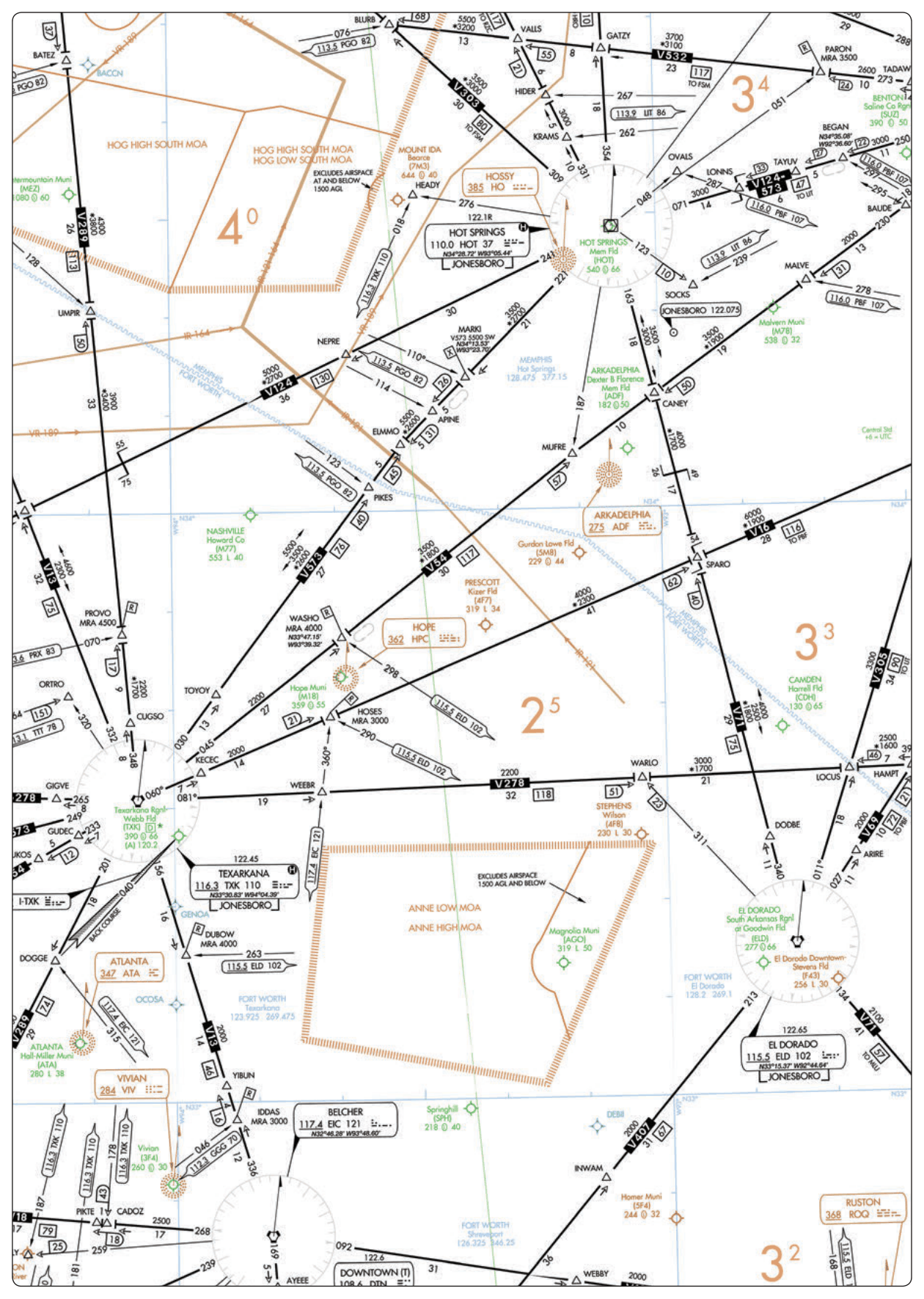
FAA Airman Knowledge Testing Supplement FAA-CT-8080-3F, Figure 34. En Route Low-Altitude Chart Segment. A work of the U.S. government, free of copyright. For training only, not for navigation.
2.MOCA: obstacle clearance without the signal guarantee
The minimum obstruction clearance altitude, MOCA, provides the same obstacle clearance as an MEA, but only guarantees navigation signal reception within 22 nautical miles of the nearest NAVAID defining that route. Beyond 22 NM from the station, an aircraft flying the MOCA has legal obstacle clearance but no assurance the navigation signal is still usable. MOCA is printed below the MEA on the chart, marked with a leading asterisk, for example "*3400."
| Obstacle clearance | Signal reception guaranteed | |
|---|---|---|
| MEA | Yes (1,000 ft / 2,000 ft in mountainous terrain) | Along the entire segment |
| MOCA | Yes, same standard as MEA | Only within 22 NM of the defining NAVAID |
Quick check
An aircraft is flying a route segment at the charted MOCA, 30 NM from the defining NAVAID. What is true?
3.MRA, MCA, and MAA: the special cases
Three further charted altitudes handle situations an MEA and MOCA do not cover by themselves.
- MRA -- minimum reception altitude — The lowest altitude at which an intersection can be identified using an off-course NAVAID. Below the MRA, that fix simply cannot be reliably determined by the signal it depends on (unless DME is available and the chart indicates the fix can be identified that way instead).
- MCA -- minimum crossing altitude — Charted where a route segment ahead requires a higher MEA, typically because of steeply rising terrain or degraded signal reception. An MCA requires the pilot to begin climbing early enough to reach that altitude by the time the fix is crossed, not after.
- MAA -- maximum authorized altitude — The highest altitude at which the airway or route can be flown with assurance of receiving an adequate navigation signal. Flying above the MAA risks losing reliable guidance from the NAVAID that defines the route.
On the written test
A fast way to keep these straight for the written test: MEA and MOCA are about how low you may go; MRA is about how low you may go and still identify a fix; MCA is about how soon you must climb; MAA is about how high you may go before losing the signal.
Quick check
A route segment ahead has a higher MEA due to rising terrain, and the chart shows an MCA at the fix where that segment begins. What must the pilot do?
4.OROCA: the off-route safety net
The off-route obstruction clearance altitude, OROCA, is an off-route altitude providing obstruction clearance with a 1,000-foot buffer in non-mountainous terrain and a 2,000-foot buffer in designated mountainous terrain, printed on the folded cover of the en route chart for the area it covers. It may not provide any navigation signal coverage, ATC radar coverage, or communications coverage at all -- it is a terrain-clearance number only, intended primarily as an emergency and situational-awareness reference, not a normal cruising altitude.
When accepting a clearance below the MEA, MOCA, minimum IFR altitude, or minimum vectoring altitude, the pilot is responsible for their own terrain and obstruction clearance until reaching one of those charted minimums. If maintaining visual terrain clearance is not possible under those circumstances, the pilot should advise ATC and state intentions rather than press on assuming someone else is watching the terrain.
- What OROCA guarantees — Obstacle clearance only, with the buffer noted above -- nothing about communication, navigation, or ATC radar coverage.
- What it is for — A pilot reference for emergencies and situational awareness when operating off the charted airway structure, not a target cruising altitude for a normal flight.
5.Who actually assigns your cruising altitude
None of these charted values are, by themselves, the altitude ATC assigns for a given flight. That comes from the clearance: vertical separation between IFR flights is provided by assigning different altitudes to different aircraft, and the pilot is expected to fly exactly the altitude last assigned -- reporting any deviation, and requesting a change through ATC rather than assuming one. A cruise clearance is the one exception, authorizing pilot discretion within a stated block rather than a single fixed number.
MEA, MOCA, MCA, and OROCA set the floor a pilot may legally fly, given the route and any minimum vectoring altitude in effect; what altitude is actually flown, above that floor, is an ATC assignment the pilot is required to comply with, or promptly query if it seems unsafe or unachievable.
What to remember
- MEA guarantees both obstacle clearance and navigation signal reception along the whole segment.
- MOCA matches MEA's obstacle clearance but only guarantees signal reception within 22 NM of the defining NAVAID.
- MRA is the floor for identifying an off-course fix; MCA forces an early climb to clear rising terrain by a specific fix; MAA is the ceiling for reliable signal reception.
- OROCA is a 1,000-foot (2,000-foot in mountainous terrain) obstacle-clearance buffer for off-route emergencies, not a cruising altitude, and offers no guarantee of signal, radar, or communications coverage.
- ATC assigns the actual cruising altitude through the clearance; the charted minimums only set the legal floor.
Key terms
Try to recall each definition before turning the card.
FAA sources for this lesson
- Instrument Flying Handbook (FAA-H-8083-15B), Chapter 1 -- The National Airspace System, IFR En Route Charts
- Instrument Procedures Handbook (FAA-H-8083-16B), Chapter 2 -- En Route Operations, Off-Route Obstruction Clearance Altitude
End-of-lesson quiz
1.What does the MEA of a route segment guarantee that the MOCA does not?
2.A minimum crossing altitude (MCA) is charted at a fix. What is the correct technique?
3.What buffer does OROCA provide over terrain in non-mountainous areas?
4.A pilot is accepting a clearance below the charted MEA of a route segment. Who is responsible for terrain and obstruction clearance until reaching the MEA?
5.What actually determines the specific cruising altitude a pilot flies on a given IFR flight?