The IFR route structure
Victor airways, jet routes, T and Q routes, and random RNAV routes.
12 min read · The IFR system and its rules
After this lesson you can
- Identify Victor airways, jet routes, and RNAV T/Q routes by their designators and altitude bands.
- Explain what a Federal airway's lateral and vertical limits actually are.
- Describe how a random RNAV route differs from a published airway, and what ATC requires to approve one.
Before GPS, every IFR flight in the United States moved along a fixed grid of electronic highways built on ground-based navigation aids. That grid still exists, still fills the low-altitude en route charts, and still shows up in clearances every day -- even a GPS-direct routing is usually cleared relative to it. Reading the chart means recognizing what kind of route is drawn and which airspace it lives in.
This lesson covers the four families of route a pilot will see on an IFR en route chart: Victor airways, jet routes, RNAV T and Q routes, and the random, point-to-point RNAV routing that increasingly replaces all three.
1.Federal airways: the highway system
The Federal Airways System is the primary structure for routing IFR traffic. Each airway is built on a centerline running from one NAVAID, waypoint, fix, or intersection to another, with the airway itself occupying the airspace within 4 nautical miles of that centerline on either side. As with all instrument flight, courses on an airway are magnetic and distances are in nautical miles.
Vertically, a Federal airway's floor is 1,200 feet AGL unless a chart specifies otherwise, and it excludes any prohibited airspace it might otherwise pass through.
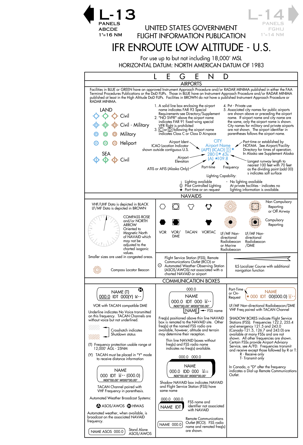
FAA Airman Knowledge Testing Supplement FAA-CT-8080-3F, Legend 33. IFR En Route Low Altitude (U.S.). A work of the U.S. government, free of copyright. For training only, not for navigation.
2.Victor airways: the low-altitude grid
Victor airways occupy the airspace from 1,200 feet AGL up to, but not including, 18,000 feet MSL -- the low-altitude structure. They are labeled with a "V" followed by a number, most often odd-numbered when the airway runs roughly north-south and even-numbered when it runs roughly east-west. Where more than one airway shares the same segment, the numbers are listed together, for example "V287-495-500."
- Numbering by orientation — North-south Victor airways typically get odd numbers, east-west airways even numbers -- a quick way to guess an airway's general direction before ever looking at the chart.
- Confluence points — Where several Victor airways share one stretch of centerline, the chart lists all their numbers together rather than drawing separate lines.
A federal airway is a corridor 4 NM wide on each side of the centerline, floor 1,200 ft AGL unless otherwise noted. Charted altitudes do not all mean the same thing: the MEA guarantees both reception and obstacle clearance, the MOCA guarantees clearance alone with reception limited to 22 NM from the facility.
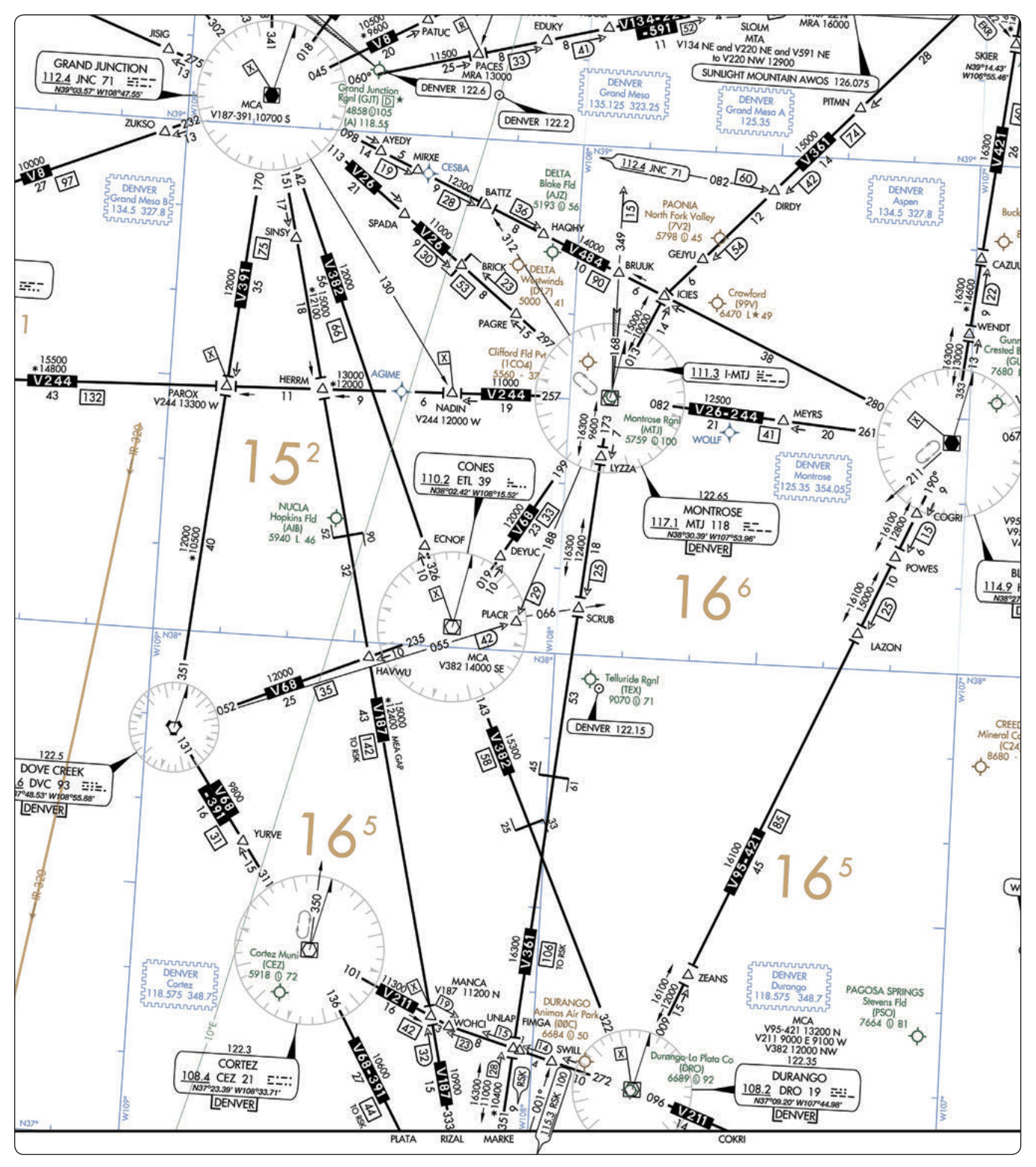
FAA Airman Knowledge Testing Supplement FAA-CT-8080-3F, Figure 24. En Route Low-Altitude Chart Segment. A work of the U.S. government, free of copyright. For training only, not for navigation.
Quick check
What altitude band do Victor airways occupy?
3.Jet routes: above the floor, inside Class A
Jet routes exist only within Class A airspace, from 18,000 feet MSL up to FL450, and are shown only on high-altitude en route charts. They carry a "J" prefix before a number, for example J12, and are built on NAVAIDs spaced no more than 260 nautical miles apart, since the airway is designed for the longer, faster legs typical of jet cruise altitudes.
4.RNAV routes: T low, Q high
RNAV routes have their own designators, separate from Victor airways and jet routes, and are depicted in aeronautical blue on the charts. Low-altitude RNAV routes carry a "T" prefix; high-altitude RNAV routes carry a "Q" prefix (with the exception of the Q-routes in the Gulf of Mexico region). Both exist specifically to give RNAV-capable aircraft more direct routing than the older airway grid allows.
Where a Victor airway and an RNAV route share the same corridor, the chart depicts both together: the Victor airway in black, the RNAV data in blue, each with its own identification box.
5.Random RNAV routes
Beyond the published T and Q routes, ATC can approve a random RNAV route: a direct, point-to-point routing based on the aircraft's own RNAV capability, defined by waypoints given as latitude/longitude, degree-distance fixes, or offsets from an established route. Approval depends on ATC's ability to provide radar monitoring and on how the route fits existing traffic volume and flow -- every random RNAV flight is radar monitored, but the navigation itself remains the pilot's responsibility, not ATC's.
- Radar required — Random RNAV routes can only be approved in a radar environment, and ATC monitors each flight on it.
- Navigation stays with the pilot — Radar monitoring is not navigation guidance -- flying the route accurately remains entirely the pilot's job.
- Special use airspace — A random route should be planned to avoid prohibited or restricted airspace by at least 3 nautical miles; a bend to route around special use airspace still needs a defined turning point.
Quick check
What does ATC guarantee when it approves a random RNAV route?
6.Other routing: preferred routes and Tower En Route Control
Preferred IFR routes exist between busy terminal pairs to guide route planning, minimize changes once airborne, and keep Federal airway traffic orderly; both low- and high-altitude preferred routes are listed in the Airport/Facility Directory by departure and arrival airport. Tower En Route Control (TEC) is a separate program using overlapping approach-control radar to move a flight from one airport tower's airspace to another's without ever handing off to Center, which can mean simpler filing and reduced separation requirements -- though its availability depends entirely on local workload and procedures.
Pilot tip
Checking the A/FD for a preferred route before filing can shortcut a lot of guessing: if one exists for your city pair, it tells you almost exactly what ATC is going to clear you on anyway.
What to remember
- A Federal airway extends 4 NM either side of its centerline, with a floor of 1,200 feet AGL unless charted otherwise.
- Victor airways (V) occupy 1,200 feet AGL up to, but not including, 18,000 feet MSL; jet routes (J) occupy 18,000 feet MSL to FL450, inside Class A only.
- RNAV routes use a "T" prefix at low altitude and a "Q" prefix at high altitude (except in the Gulf of Mexico), depicted in blue.
- A random RNAV route needs ATC approval and radar monitoring, but navigation accuracy remains the pilot's job, not ATC's.
- Preferred IFR routes and Tower En Route Control both exist to simplify routing between busy airports; check the A/FD before filing.
Key terms
Try to recall each definition before turning the card.
FAA sources for this lesson
- Instrument Flying Handbook (FAA-H-8083-15B), Chapter 1 -- The National Airspace System, Federal Airways and IFR En Route Charts
- Instrument Procedures Handbook (FAA-H-8083-16B), Chapter 2 -- En Route Operations
End-of-lesson quiz
1.How far does a Federal airway extend on each side of its centerline?
2.Jet routes exist:
3.A low-altitude RNAV route on an en route chart would be labeled with which prefix?
4.What is required for ATC to approve a random RNAV route?
5.Where can a pilot find published low- and high-altitude preferred IFR routes between two airports?